
“The Hoboken Meadows” is now on display at the Hoboken Historical Museum
FBW | February 20, 2025

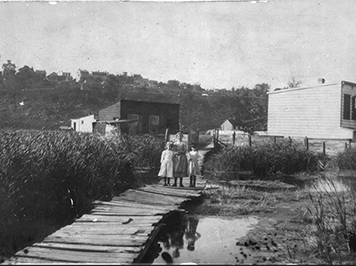
In the 1700s, Hoboken was an island. This is documented in the new exhibition, “The Hoboken Meadows,” at the Hoboken Historical Museum. The island, the elevated area around Castle Point, comprised about 25 percent of Hoboken’s current land mass. The remainder of Hoboken was a wetland, a salt marsh — The Hoboken Meadows.
The Federal Emergency Management Agency’s (FEMA) flood maps designates 75 percent of Hoboken as a flood hazard zone, which is remarkably similar to the area that once comprised the wetland area. As depicted in the Historical Museum’s exhibit, Superstorm Sandy in 2012 flooded the low-lying areas of Hoboken, returning the town to its prior configuration of an island surrounded by water. Sandy, a storm surge event, headed north along the Atlantic coastline, making a direct hit into the New York Harbor. Mother Nature attempted to reclaim what once belonged to her.
In 1784, at a public auction, Col. John Stevens purchased the land that would become Hoboken. In order to develop the area, the wetland was gradually filled. In 1804, Col. Stevens hired the surveyor Charles Loss to lay out a plat map for Hoboken, establishing a uniform street grid. That map indicates where portions of the wetlands were filled. The map extends south to Philadelphia Post Road, now Newark Street, west to Willow Avenue and north to Eighth Street.
Hoboken’s first development boom took place at the turn of the 20th Century. Continued dumping of fill into the Hoboken Meadows allowed the city to eventually expand west to the Palisades and north to 16th Street. Plat maps in successive years documented this growth, with Col. Stevens’ street grid of 1804 being uniformly extended throughout the municipal boundaries.
Today, the low-lying areas of Hoboken are subjected to perennial flooding by major rain events and exacerbated by climate change. Superstorm Sandy was very different: the worst flooding in memory resulted not from rain but from a surge pushing the waters from the Atlantic Ocean into New York Harbor. A 2016 flood hazard assessment of the New York Harbor estimated that the last surge event similar to Sandy occurred some 260 years prior.
In response to Sandy, the federal government created the Rebuild by Design program that awarded large grants for ten projects to create innovative solutions to address flooding issues in the northeast Atlantic region. Hoboken, including a small portion of Jersey City and Weehawken, was awarded a $230 million grant.
The Hudson River Rebuild by Design Project (RBD), as it is called, proposed a comprehensive strategy for the Hoboken area, consisting of Resist, Delay, Store, Discharge. The RBD team stated, “Our comprehensive strategy deploys both hard infrastructure and soft landscape for coastal defense (resist); recommends policies to enable the urban fabric to slow down water (delay); a green circuit to trap water (store) and water pumps to support drainage (discharge).”
After ten years of planning and design work, the project is now being built. The resist floodwall is under construction. Newly built parks in the western, low-lying areas have the capacity to store millions of gallons of stormwater underground. New high-capacity pumps have been put into operation. The North Hudson Sewerage Authority has installed additional sewer infrastructure, including separating some of the combined sewer and stormwater pipes at the north end of town.
In 2019, the State of New Jersey took control of the Hudson River Rebuild by Design project. Over the years the cost to implement the various strategies has risen considerably. The original estimate to build the “resist” floodwall, $230 million, is now $392 million. The state has invested another $100 million into the RBD project that includes construction of the park at the Weehawken Cove, with a massive anchored concrete floodwall hidden within the landscape design.
The museum exhibit describes the abundant flora and fauna that flourished in the Hoboken Meadows. Today, the nearby New Jersey Meadowlands provides a picture of what much of Hoboken looked like in the 1700s. Take a bird walk in the NJ Meadowlands and one might sight Osprey, Blue Heron, Great Egrets, Cormorants, Sandpipers, Peregrine falcons, Snowy Owls, Bald Eagles, American Coots, Black Skimmers and Black Crown Night Herons. One might also spot Diamondback Terrapins, Red Foxes, Meadow Voles, Northern Harrier and Muskrats. Phragmites and cordgrass are abundant in these marshlands.
The Hoboken Historical Museum will present two lectures connected with this exhibit. The first, on Sunday, March 2 at 4 pm, will be a lecture on the history of the New Jersey Meadowlands by Terry Doss, a restoration ecologist who serves as Director and Chief Restoration Scientist for the Meadowlands Research and Restoration Institute. The second is a lecture by Captain Bill Sheehan, the Hackensack Riverkeeper, on his decades-long advocacy and education work for the Hackensack River watershed. Captain Sheehan’s presentation is on Sunday, April 6 at 4 pm.
The Hoboken Historical Museum is located at 1301 Hudson St., Hoboken.
Related Webpages
Flood Hazard Assessment for New York Harbor
City of Hoboken Flood Mitigation
Related Links
Hoboken model to mitigate flooding dependent on massive gov’t support as costs rise and major rain storms intensify
Hoboken floods worsen as Ida, Henri put stormwater management strategies to the test
Rebuild by Design floodwalls would have had no impact on Friday’s flash flooding
New York City’s flood hazard maps found to be inaccurate; so what about Hoboken?
Sea level rise will put half of Hoboken underwater by the next century
Are Hoboken’s proposed floodwalls based on overstated risk of another Superstorm Sandy?
What are the best strategies for making Hoboken flood-resilient?
Walling off Hoboken’s waterfront meets fierce resistance
Dutch-led team: Resist, Delay, Store, Discharge: a comprehensive strategy for Hoboken
Are we devising flood remedies based on a 1,000 year storm?
79% of Hoboken falls into FEMA’s new flood zone!