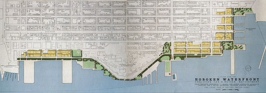
We began in 1990 with the belief that the water’s edge belongs to the public: no one should question a person’s right to fish, stroll, sunbathe, read, nap or simply be there. We drafted a plan for Hoboken’s waterfront; at its center was a continuous, public park along the Hudson River, uninterrupted by private development.
The first step in the planning process involves mapping the public street system. FBW began by extending the existing public street grid to the waterfront, ensuring that new blocks for private development were typical Hoboken-sized blocks that fit into the current scale of the city. The last street at the waterfront, Sinatra Drive, became the dividing line between these new blocks for private development and the continuous park at the water’s edge. Once someone crosses Sinatra Drive, they know instinctively they have entered a public realm – a park.
Extending the public street grid also ensured that buildings’ front doors faced the waterfront, providing an opportunity to create a lively streetscape with shops, restaurants and cafes along the water. Elsewhere, where communities failed to extend the public streets to the waterfront, back doors face the waterfront, cutting off public access and diminishing the public nature of this space.
Related Links
FBW’s 30-year history
A prophetic vision for successful and failed waterfronts
Col. Stevens’ vision for Hoboken still valid 200 years later
Hoboken’s original plan and first parks established in 1804
Roots over the river
FBW waterfront plan featured in Designing New Jersey (October 2000)
Urban Design Principles that Make for Successful Waterfronts