The NYC Tree Map is the most comprehensive and up-to-date living tree map in the world
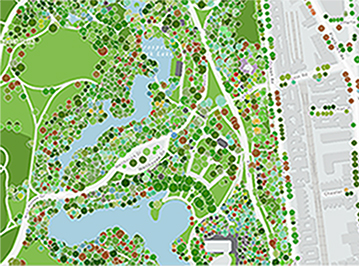
 Detail of NYC Tree Map showing a portion of Prospect Park in Brooklyn and streets to the east.
FBW | January 2, 2023
On the south shore of Prospect Park Lake in Brooklyn, stands an immense American basswood tree with a trunk that measures 60 inches in diameter. This basswood dominates a cluster of trees, two smaller basswoods, a mulberry, a pin oak and a willow. Nearby is an Ohio buckeye and a large white ash. Each year, this single 60 inch American basswood can intercept over 5,000 gallons of stormwater and remove 8,637 tons of carbon dioxide. The tree also reduces four pounds of air pollutants annually. I know all this because I consulted the newly updated New York City Tree Map.
By using this map, I am able to identify the species, size, location and condition of 862,660 trees located in New York City’s parks and on the city’s streets. The map identifies 536 different tree species, the most common by far being the London plane tree representing 10 percent of the total trees. The New York City Parks Department logo is a representation of a London Plane tree leaf.
The New York City Tree Map website describes the value provided by these trees: “New York City’s trees shade us in the summer, beautify our neighborhoods, help reduce noise, and support important urban wildlife. Beyond these priceless benefits, our urban forest provides us a concrete return on the financial investment we put into it. Our publicly owned trees are as much of an asset to us as our streets, sewers, bridges, and public buildings.”
Certain trees, such as the London plane tree, known to survive harsh urban environments, can live to be 200 years old. Thus, for a modest investment an appropriate species of tree provides multi-generational benefits.
The map website details the aggregate benefits of the 862,660 trees, using formulas developed by the U.S. Forest Service. Each year, the trees currently mapped are responsible for absorbing 1.4 trillion gallons of stormwater, conserving 815 million kilowatt hours of energy, removing 1.5 million pounds of air pollutants and reducing carbon dioxide by 1.5 million tons. The economic value of these trees totals $129 million on an annual basis.
The New York City Parks Department inspects the trees in its parks and on the city streets, and this information is recorded on the tree map. In addition, the map facilitates the stewardship of trees by local citizens and organizations. The Parks Department trains volunteers on best practices in caring for trees including the basics of watering, mulching and weeding.
In 2016 through 2018, Parks Department staff and volunteers participated in a Park Tree Inventory. This was expanded further in November 2021 when the New York City Council signed Local Law 20 of 2021 requiring the Parks Department to maintain a regularly updated map. Central Park, which is maintained by the Central Park Conservancy, not the Parks Department, is not yet included but its trees are currently being surveyed for future inclusion.
For the NYC Tree Map to be fully functional, it is necessary to register on the website. This allows one to have full access to this extraordinary database.
Related Links
New York City Tree Map
With rows of shade trees, a model for trees in urban design
Landscape design for Columbus Park still shines 108 years later
Urban shade trees are the key to building sustainable, healthy cities
The morning after Superstorm Sandy: Hoboken’s waterfront parks
Public parks provide essential benefits
Col. Stevens vision for Hoboken still valid 200 years later
Plan for the Hoboken Waterfont
Roots over the river