
 Planner testifying before Planning Board cites the part of Weehawken built 100 years ago as a model for creating walkable, close-knit neighborhoods and a basis for good planning today.
FBW | June 19, 2020
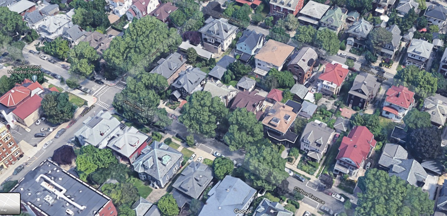
Weehawken is divided into two distinctly different communities. Most of its long-established residential area was built atop the Palisades 100 years earlier. This cozy neighborhood consists of many closely-spaced, single family homes on small lots. To the west, bordering Union City, Park Avenue provides a nearby commercial strip. To the east of Hamilton Avenue and John F. Kennedy Boulevard, a popular linear park lines the top of the Palisades, offering spectacular views of midtown Manhattan and the Hudson River.
Several hundred feet below, at the base of the Palisades, are hundreds of acres of land along the Hudson River waterfront. This land was formerly devoted to ferries and extensive commercial railroad lines as well as piers. By the 1980s, as the industrial uses died out, Hartz Mountain Industries acquired a 50-acre site to the south and Arthur E. Imperatore, Sr. the land to the north for redevelopment. What followed has been intense development on a dramatically different scale and character than what had been built in an earlier era.
On May 19, 2020, Maryann Bucci-Carter, a planner, testified before the Weehawken Planning Board. She explained that the latest thinking on urban redevelopment is “based on principles of how cities and towns developed in the last century, which is how Weehawken developed.” She explained that in upper Weehawken the layout of the streets is traditional. “They’re walkable blocks and streets. The housing and shopping is in close proximity. There’s accessible public spaces . . . the buildings are focused on human-scale planning and design.”
Ms. Bucci-Carter testified on behalf of neighboring property owners and the Fund for a Better Waterfront that have been represented by counsel in opposition to the latest project proposed by Hartz Mountain. The hearings for what is called the Atir site began on February 4 after the Weehawken Planning Board rejected an earlier, taller project. At the last hearing on May 28, the Board approved the application for two 160-foot towers atop a massive 7-story parking garage. The footprint of this structure abuts the 30-foot wide state-mandated Hudson River Waterfront Walkway along the Weehawken Cove.
In her testimony, Ms. Bucci-Carter pinpointed the essential problem with the Weehawken project: its failure to create a real neighborhood. She also described a recent planned development in Jersey City, Liberty Harbor North, that successfully created a neighborhood feeling by first laying out an extensive, traditional-style street grid, that established clearly defined development parcels. Facing the street are a mix of residential and retail uses. Walking down the blocks, one sees stoops, front doors and windows. Parking garages at the interior of the blocks are concealed behind the residential and retail uses. The plan for this 100-acre project was created by the noted urban planner Andres Duany.
Ms. Bucci-Carter stressed the importance of the extensive street system at Liberty Harbor North, which provides public right-of-ways throughout the site. This is lacking at Weehawken’s Lincoln Harbor, which has just a few private roadways all devoid of parking. She also pointed out that the massive seven-story parking garage at the base of the Atir project results in a blank wall, devoid of life and activity at ground level and along the Waterfront Walkway.
Over a 29-year period, Ms. Bucci-Carter of CME Associates served as a principal planner and eventually the Director of the Jersey City Planning Department, working on a series of waterfront redevelopment plans including the Liberty Harbor North project. Currently, she is also a professor at Edward J. Bloustein School of Public Policy and Planning at Rutgers University.
On the same evening, Robert Costa of Costa Engineering testified on behalf of the objectors. He pointed out that the applicant’s site plan, and its survey and subdivision plans, did not correspond to one another. Although the Atir site is limited to 2.2 acres, Hartz has attempted to use additional acreage at their Lincoln Harbor development to meet bulk and area coverage requirements. Mr. Costa also pointed out that part of the building structure intruded into the 30-foot easement for the Hudson River Waterfront Walkway.
Both Mr. Costa and Ms. Bucci-Carter testified that the Atir project failed to meet a long list of Weehawken zoning ordinance requirements including maximum lot area, front yard setback, rear yard setback, maximum improvement coverage, maximum floor area ratio and density.
Last December, the Township of Weehawken amended its redevelopment ordinance to accommodate the two 160-foot towers in Hartz’s recently approved project. The following month, two of the neighboring property owners, Rock Eagle Properties and 1715 Grand Street LLC filed suits challenging this ordinance stating that it constituted “spot zoning” designed specifically to benefit Hartz’s application to build on the Atir Site. FBW also filed a legal challenge to the ordinance due in part to the failure of Weehawken to update its 35-year old master plan as required by state law. It is expected that there will also be a legal challenge to the May 28 Weehawken Planning Board approval.
Related links
Liberty Harbor North Redevelopment Plan
Multiple lawsuits challenge new ordinance for Lincoln Harbor
Planning Board votes down high-rise towers at Weehawken Cove after persistent opposition
Objectors mobilize against massive towers proposed at Weehawken Cove
Making up Hoboken’s open space deficit at the waterfront & how to fund it
Public parks provide essential benefits
Col. Stevens vision for Hoboken still valid 200 years later
Editorial: A Once-in-a-century Opportunity
NJ-APA 2013 Great Places in NJ
Plan for the Hoboken Waterfont
Hoboken’s first parks established in 1804