By Ron Hine | FBW | September 10, 2012
The gateway to Hoboken, an underutilized rail yard on the city’s southern border, is ripe for change and a grand opportunity for us. Unfortunately, the competing plans now being put forth by the City and New Jersey Transit are fundamentally flawed. We are particularly disappointed with the plan proposed for the City by its consultant Wallace Roberts and Todd (WRT).
No new streets. The first and most basic step in a redevelopment plan is laying out the streets. New York City adopted the Commissioners Plan of 1811, which platted streets; streets which guided development, but which were not built upon for a century. In 1804, Col. John Stevens hired surveyor Charles Loss to create a plan for Hoboken’s streets, blocks and lots, laying the framework for future development. It designated Hoboken’s first parks. The Hoboken Yard Redevelopment Plan by WRT proposes new residential and commercial buildings on a “super block,” neither delineated nor described. New streets, streets that can be mapped — the public rights-of-way — are absent.
No new parks. Although the WRT plan gives considerable lip service to public open space, there are no provisions for public parks. Rather, “mini-plazas” serve as front or side yards to private development. Left to private developers, many examples show these areas fail as truly public spaces. In Hoboken, the “park” at Newark and Garden Streets is inaccessible to the public despite promises to the contrary. The triangular park directly south and adjacent to Maxwell Place has been under dispute since it opened. As an example, across the river, the 1969 plaza bonus program in New York City — an attempt to create “public” space on private property — is seen as a failure.
Hoboken’s South Waterfront Redevelopment Plan included over 10 acres of new public park: Pier A, Pier C and the promenade from Newark to Fourth Streets. The WRT Hoboken Yard Redevelopment Plan adds none. Warrington Plaza has always been a public area despite New Jersey Transit’s recent use of the area for parking. Hudson Place is currently a public right-of-way. Green roofs don’t count as open space.
Failure to echo Hoboken’s urban character. Buildings in Hoboken, as in other dense urban areas, hug the front lot line in continuous rows. Front doors face the street. The WRT plan orients most of the buildings perpendicular to Observer Highway with an odd array of setbacks. Observer Highway, the widest street in Hoboken, should look to exemplary models for how it can be developed. The Grand Concourse in the Bronx comes to mind. Central Park West and Park Avenue in New York City are also models. It is difficult to think of a successful boulevard where buildings on one side face the street, and those on the other side are perpendicular to the street.

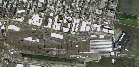
Hoboken Rail Yard slated for redevelopment along Observer Highway and adjacent to Train Terminal.
There are many other deficiencies with this plan. Closing Hudson Place will be the death knell of retail shops on that street. The performing art center is just window-dressing unless there is a developer in hand ready to build such a facility. The same applies to other proposed uses – the market will dictate what gets built. Without expertly crafted design guidelines, the architecture is likely to disappoint.
The 1995 South Hoboken Waterfront Redevelopment required the Port Authority to invest tens of millions of dollars to build parks, a new street system and other infrastructure. It is an acclaimed success. The Hoboken Yard Redevelopment Plan includes no such investment that would benefit the public. Unless the plan is altered in some fundamental ways, this will be an opportunity squandered.
Related links
Mapping and Platting
Public vs. Private
Privatizing the Planning Process

