By Ron Hine | FBW | November 7, 2012
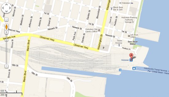
The Long Slip Canal in Jersey City runs for more than ¼ mile just to the south and parallel to the NJ Transit train tracks leaving the Hoboken Train Terminal. This canal provided a channel for the powerful surge from the NY Harbor and the Hudson River that severely flooded the southern and western portions of Hoboken.
Monica Pollock and her husband live on the tenth floor of 415 Newark Street, Hoboken that overlooks the tracks, Observer Highway and Luis Marin Boulevard. They observed the Long Slip Canal overflowing as early as 8 p.m. the first night of super-storm Sandy. Subsequently, in her words, all hell broke loose. She stated, “The water was so powerful from the canal that there were 3 to 4 foot waves coming into Hoboken from Marin, also a tremendous flow from the front of the old NJ Transit maintenance building.”
Marin Boulevard, formerly Henderson Street, is Hoboken’s first exit when traveling west on Observer Highway, leading directly to Jersey City before going under the train trestle. The Jersey City Building Department ordered the evacuation of 400 people living at two 10-story buildings in Jersey City at Marin Boulevard just north of the train trestle. The Zephyr Lofts and 700 Grove Street have a common garage and according to Director Ray Meyer of the Building Department, quoted in the Jersey Journal, “during flooding, water apparently created a ‘buoyancy’ issue which lifted the concrete slab at the base of the garage, possibly damaging columns supporting the buildings.”
If the canal was the primary source of the flooding in southwest Hoboken, it may also point to the solution for preventing the next occurrence. Sea walls are a common remedy and the construction of a sea wall perhaps combined with floodgates at the entrance to the Long Slip Canal could be a basic preventive measure.
According to a November 6, 2012 NPR report, “Tide gauges show the relative water level around Norfolk, Virginia is more than 14 inches higher than it was in 1930. And the rate of sea level rise is increasing, especially between North Carolina and Boston.” The city of Norfolk, Virginia has hired Fugro, a Dutch company, to come up with a long-term plan to keep the water out of several vulnerable neighborhoods. One of the projects has a Dutch name, The Hague which has created an encapsulated basin with a small gated outlet. The gate can be closed, thus providing a barrier during a tidal storm.
A number of soft infrastructure solutions could provide additional protection. A New York Times article on November 4, 2012, “Protecting the City, Before Next Time” talks about re-engineering New York’s waterfront to withstand a super-storm. One proposal is to create tidal marshes or mossy wetlands to absorb waves along Manhattan’s shoreline.
A prescient exhibit at the Museum of Modern Art entitled “Rising Currents – Projects for New York’s Waterfront” ended a year ago. The exhibit responded to the urgent challenge of rising sea levels caused by global climate change and was put together by five teams of architects, planners, ecologists and installers. Among the proposals for New York City were to restore wetlands areas, create streets that would absorb water like a sponge, create islands of mussels and oysters that would buffer storm surges, construct artful reefs from recycled glass, provide barriers across channels that could be inflated during storms and build sunken parks that could take in water during a storm.
At a press conference last week, New York Governor Andrew Cuomo stated, “Climate change is a reality. Given the frequency of these extreme weather situations we have had, for us to sit here today and say this is once in a generation and it’s not going to happen again, I think would be shortsighted.”
Most of Hoboken is buffered from its waterfront by the highest ground in town at Castle Point and at Hudson and Washington Streets, just a few blocks inland. This area experienced little or no flooding during super-storm Sandy. Typically, flooding occurs in areas of Hoboken below sea level during heavy rainfalls but the recent storm brought minimal rain. The flood waters breached at the south and at the north end of town at the Weehawken Cove where additional protections are needed. Another consideration would be the water that backed out of the sewer system and if flood gates currently in place were inadequate to handle the rising waters.
Related links
Dutch Dialogues: a model for Hoboken
Flood insurance rates will skyrocket
Monarch Towers now in FEMA’s Coastal High Hazard Flood Zone
79% of Hoboken falls into FEMA’s flood zone
Post Sandy: After repairing the damage, then what?
12-Point Plan in preparation for the next Sandy
The morning after Sandy: Hoboken’s waterfront parks
Sandy, the day after – Hoboken waterfront pics
Roots over the river

