By Ron Hine | FBW | May 8, 2013
June 5, 2013 Update: Politics trumps public policy as the New Jersey State Senate on May 30th passed S-2680 by a vote of 27 to 3. The bill now moves on to the Assembly as A-3933 and is scheduled to be taken up by the Assembly Environment Committee this Monday June 10 at 2 pm at the Statehouse Annex. State Assemblyman Ruben Ramos who sits on the Environment Committee has stated his opposition to this legislation.
Hurricane Sandy taught everyone a hard lesson about the perils of building too close to the water. The images of mass destruction along the coastlines of New York and New Jersey are now etched clearly in to our minds. And the stories of families and businesses devastated by the storm abound.
Earlier this year, FEMA released its Advisory Base Flood Elevation Maps for the NJ coastline, revised for the first time in 25 years. The current flood zones are now greatly expanded, including a strip along most of the region’s shoreline determined to be at highest risk, termed the “Coastal High Hazard Zone.”
Section 3.18 of the New Jersey Department of Environmental Protection (NJDEP) Coastal Zone Management Rules (N.J.A.C. 7:7E) prohibits multi-family residential development, including hotels and motels, and discourages commercial development in the Coastal High Hazard Zone. FEMA designates this area with the highest risk of flooding because, in the event of a tropical system like Sandy, there is a high probability of breaking waves and a destructive combination of tidal and wind-induced storm surge. As a result of FEMA’s expanding the Coastal High Hazard Zone, the prohibition of development extends the entire Hudson River coastline from Bayonne to Fort Lee, New Jersey.
In the months following Sandy , New York Governor Andrew Cuomo announced a $400 million buyout program to purchase vulnerable homes built along the shoreline. In proposing this program, Cuomo stated: “There are some parcels that Mother Nature owns. She may only visit once every few years, but she owns the parcel.” New York City Mayor Michael Bloomberg has proposed a similar program as did New Jersey Governor Chris Christie in a $250 million program to purchase flood-prone properties, with the exception that entire neighborhoods (not individual homeowners) consent to any buy-out.
The new FEMA flood maps are intended to keep people out of harm’s way. Yet, New Jersey State Senator Nicholas Sacco of Hudson County and Joseph Kyrillos, Jr. of Monmouth County have introduced Senate Bill 2680 to remove the prohibition on building multi-family residential, motels and hotels on piers in FEMA’s Coastal High Hazard Zone for certain municipalities. Piers which jut out over the water, like those found on the Hudson River, pose the most vulnerable sites for private development within this newly determined high risk area.
It just defies common sense, after coming through Sandy, to remove restrictions on building in high-hazard areas.
In response to S2680, Tim Dillingham, executive director of the American Littoral Society, stated in an article featured on NJ Spotlight, “It just defies common sense, after coming through Sandy, to remove restrictions on building in high-hazard areas.”
Section 3.18 of New Jersey’s Coastal Zone Management regulations do not apply to certain single family and duplex developments. Atlantic City is also excluded.
Scientists and climate experts such as geophysicist Klaus Jacob from the Columbia University Lamont-Doherty Earth Observatory agree that people are in denial about the dual threats of climate change and rising sea levels. The scientific community has reached the general consensus that future storms, climbing in both frequency and intensity, will force people living in the region to retreat from the most vulnerable portions of the water’s edge.
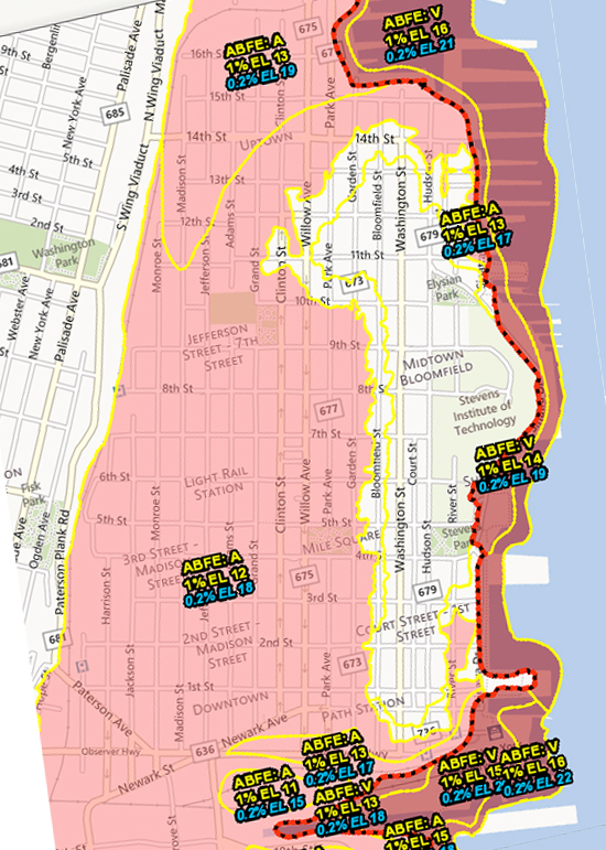
Dark red area indicates FEMA’s Coastal High Hazard Zone for Hoboken coastline.
The State of New Jersey’s authority to regulate development along the Hudson River and other coastlines derives from the Public Trust Doctrine. This doctrine, part of common law in the U.S., holds that navigable bodies of water as well as land at the water’s edge that were formerly flowed by the tides are held in trust by the state for the benefit of the public for a wide array of uses.
The NJDEP’s regulations pertaining to the Hudson River allow for private non-water dependent development on these public trust lands, including what is termed the “filled-water’s edge,” in exchange for building the Hudson River Waterfront Walkway, the 18-mile, 30 foot wide public walkway, now largely complete from the Bayonne Bridge to the George Washington Bridge.
During Sandy, the damage to buildings located on piers in the New York Harbor area, was extensive. For example , the surge from Hurricane Sandy filled the 28-acre Chelsea Piers Sports & Entertainment Complex with five feet of water. The lower floors of this facility on the Hudson River suffered extensive water-related damage ultimately requiring millions of dollars in repairs.
Related links
Monarch Towers now in FEMA’s Coastal High Hazard Zone
A serious conversation about Sandy
Flood insurance rates will skyrocket
79% of Hoboken falls into FEMA’s flood zone
Post Sandy: After repairing the damage, then what?
12-Point Plan in preparation for the next Sandy