Sidewalk Labs’ former plan for the Toronto lakefront, aimed to make Toronto the global hub for urban innovation but failed to delineate public space at the water’s edge from upland private development.
By Craig Whitaker | Craig Whitaker Architects | May 27, 2020
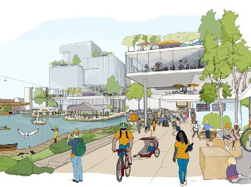
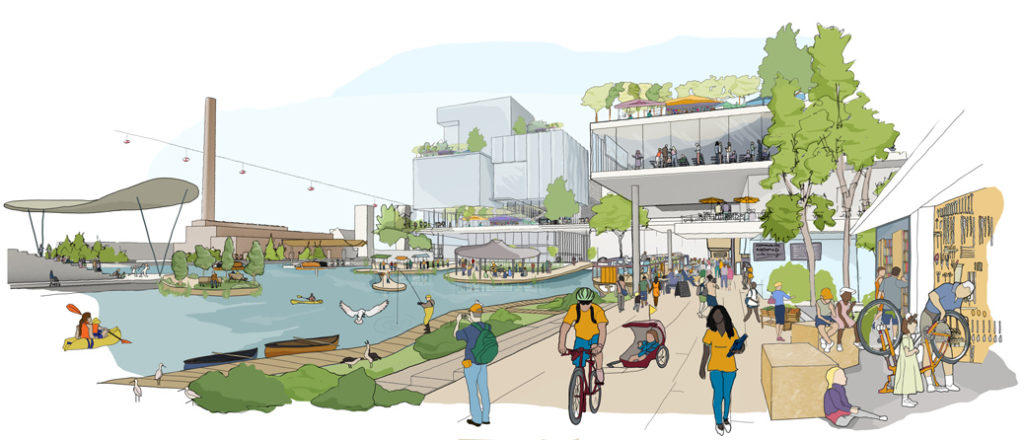
The recent announcement that Sidewalks Lab was abandoning its plan for redeveloping 800 acres of the Toronto lakefront now offers the city a once in a lifetime opportunity to get it right, to create a real world-class waterfront. The Sidewalks Lab plan was essentially a real estate venture designed to get Google to the lake. That was a subtle, but vastly different goal than getting Toronto to the lake. Early Google sketches showed all the obligatory features of a happy pedestrian waterfront. There were sea gulls, sailboats and people who were grateful to be there.
A closer look, however, showed that there was no delineation between public and private land. Google’s front doors opened onto the lake. Properties had walkways and verandas, of course, but they were attached to the buildings behind. Everyone traversing the walkways was on Google land.
Suppose now Toronto were to declare that it wanted a waterfront park that stretched the length of the 800 acres, perhaps even beyond. That decision would immediately bring to mind examples like Rio de Janeiro with its Copacabana, or Miami Beach, Riverside Park in Manhattan or the lakefront of Chicago and the salutary effect all have had on the character of their respective cities.
Each is different from the other, but all have a common feature – they are all bounded by a street. A street does not mean a highway or even a broad boulevard. It just means a simple street delineating public park from private land, creating a bright line between Mammon and God. The character of the street and its role is an important point to empathize early given the pain and dislocation the Gardner Expressway has caused.
Toronto’s first step would be to decide how big the park will be and to create its boundaries even if at first these exist only on paper. It is worth remembering that six city aldermen set aside land for New York’s Central Park several years before Frederick Law Olmsted and Calvert Vaux were chosen to design it. The character of the waterfront, which may vary greatly, is less important than that the park be continuous.
The former industrial land bordering the Inner Harbor is punctuated by slots of water like driveways which allowed boats and barges to load and unload from both sides. Some may now be filled but for those that remain there will need to be bridges crossing the breaks. The Ponte della Paglia and the other bridges fronting the Bacino in Venice come to mind. It is a moment in this city’s history to think of precedents, as well as to dream.
Toronto will also need to design the street system connecting the waterfront to the rest of the city. The city does not need real estate developers to do this. Many cities have platted land well in advance of the buildings to be built on it. It does need urban designers sensitive to the correlation between the character of a street and the ambiance of the land abutting it. Even though many streets may be sized to encourage pedestrians and bicyclists they will also need to accommodate moving vans and fire engines.
Streets delineate the land between. How big will the blocks be? What will their character be? The Commissioners Plan of 1811 in New York provides a cautionary example. It was predicated on monetizing every square foot of land. Alleys, which done correctly can provide a second scale, were deemed not necessary. This meant that the mapped area would forever be somewhat dirtier because garbage would exit from the same door through which groceries entered.
For two decades I taught a course in the graduate planning program at New York University called “Why Cities Look the Way They Do.” Every year I would ask students to choose what they thought was the most pedestrian friendly neighborhood in Manhattan and to tell me why. Invariably they picked Greenwich Village and then described the effects of the many four- and five-story buildings. Not once did anyone note that Manhattan’s other residential streets are sixty feet wide while Greenwich Village’s are typically only fifty feet. Details like this matter.
Now is the time for Toronto to plan for this extraordinary opportunity, to decide what it wants its waterfront to be. The press of development will follow soon enough.
Craig Whitaker of Craig Whitaker Architects is based in New York City. He is the author of Architecture and the American Dream. He has guided FBW’s planning and urban design efforts since 1990.
Related Links
Craig Whitaker, Architect and Urban Planner
A prophetic vision for successful and failed waterfronts
FBW video featuring Craig Whitaker
Mapping & Platting
Plan for the Hoboken Waterfront
What do Zuccotti Park & Hudson River Walkway have in common?
Privatizing the Planning Process
NY Times Book Review: Architecture and the American Dream