By Ron Hine | FBW | December 21, 2012
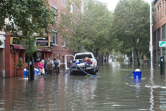
After super-storm Sandy, half of Hoboken was under water. As a result of its antiquated infrastructure, Hoboken floods often. But not in anyone’s lifetime has the City witnessed such a powerful storm and such catastrophic flooding as occurred on October 30th. Some neighborhoods experienced 3 to 4 feet of floodwaters, isolating thousands of people from any emergency services. The local hospital had to be evacuated. Cell phone service went out. The power grid was down for nearly a week for most Hoboken residents. The impact on people’s lives, on businesses, local government and community institutions was profound.
Hoboken is an interesting case study, for much of it lies below sea level. At the time Col. John Stevens founded the City of Hoboken, it was an island facing the Hudson River and surrounded by swampland and marshes in the low-lying northern, southern and western portions of town. Indeed, these were the parts of town that experienced serious flooding after Sandy’s surge breached at the north and south ends of town. But most of Hoboken’s waterfront rises quickly to the highest land in town at Castle Point and along Washington and Hudson Streets. Interestingly enough, although some of the City’s waterfront parks were damaged, others fared quite well despite the fact that they were all under water. There are some important lessons to be learned from that. (See ‘waterfront parks’ link below.)
The Long Slip Canal just to the south of the New Jersey Transit train tracks became an unimpeded channel that brought the surging water over the tracks and through Marin Blvd. into the south end of town. Millions of dollars in New Jersey Transit train equipment left on the tracks in Hoboken was destroyed. The canal is a relic of an earlier industrial era. New Jersey Transit had a permit to fill this deteriorating waterway but chose not to act on it. There are no gates or sea walls to prevent a storm surge from breaching at this location.
Hoboken is a major transit hub. 56% of the population relies on public transportation to get to work. After the storm, people had no means of egress. The PATH train that had transported 28,650 people from Hoboken to New York City ceased service out of Hoboken for 49 days. Once ferries and buses began operating, there were long lines of frustrated commuters.

First Street in Hoboken the day after Sandy hit. Photo credit: Jean-Paul Picard.
Even as people struggle to restore their lives, we must begin the work of developing viable short and long term strategies for preventing future storms from having such a devastating impact on our community. Hoboken, being just one square mile, also referred to as the “Miracle Mile,” could provide us a laboratory of sorts for developing solutions for future events. This will be a major focus of the Fund for a Better Waterfront in the next several years. For more information, follow the links below.
Related links
Dutch Dialogues: a model for Hoboken
Flood insurance rates will skyrocket
Monarch Towers now in FEMA’s Coastal High Hazard Flood Zone
79% of Hoboken falls into FEMA’s flood zone
Post Sandy: After repairing the damage, then what?
12-Point Plan in preparation for the next Sandy
The morning after Sandy: Hoboken’s waterfront parks
Sandy, the day after – Hoboken waterfront pics
The Long Slip Canal and protecting Hoboken from the next surge
